Alessandro Tibaldi, University of Milan Bicocca (Italy)
Agust Gudmundsson, Royal Holloway University of London (UK)
Greg Waite, Michigan Technological University (USA)
1. Objective
This Task Force aimed to improve international collaboration between researchers from different countries in the study of the relationships between volcanism and tectonics, with particular attention to the integration of different methodologies, including structural geology, stratigraphy, geomorphology, petrography, volcanology, geophysics, and numerical and analog modeling.
2. Major achievements
From 2021 to 2025, approximately 100 scientists have devoted themselves to the study of volcanotectonics in various regions of the world, publishing their results in 375 scientific articles (a complete list of publications is available on the Task Force II website: www.ilptaskforce2.unimib.it) and organizing 23 sessions at international conferences. Several research projects have been submitted for funding from national and international institutions, and several international schools have been organized to train young researchers.
3. Examples of relevant results
Of course, it is impossible to summarize all the relevant results achieved by the various researchers involved, and so we will focus on three topics relevant to human society, taking into account that many other examples could have been taken into consideration.
3.1. Volcanotectonics and climate changes
This is a very important thematic since volcanic eruptions can cause climate changes, as well as glacier melting above volcanic edifices, and also the consequent sea-level rise, can condition eruption frequency and intensity. Here we report a couple of examples.
Satow et al. (2021), studied the occurrence of eruptions at the active Santorini volcano in Greece, during the last 360,000 years, showing that 208 out of 211 eruptions occurred during periods constrained by sea-level falls (below −40 m respect to present sea level) and subsequent rises, a result that probably applies to many other volcanic islands around the world. In Figure 1, in fact, it can be noted that most of the volcanic activity at Santorini (black/grey areas and circles) occurred when the sea level was lower than -40 m respect to present.
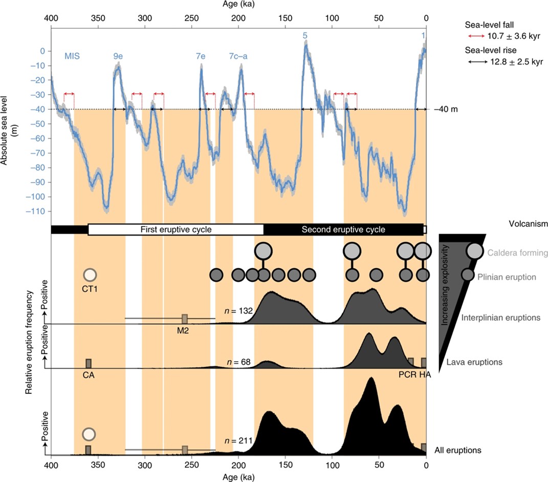
Fig. 1. Upper part:Absolute sea level variations (blue line) in the last 400,000 years. MIS is Marine Isotope Stage. Time lags between the sea level falling or rising through −40 m and the start or end of eruptive activity are denoted by red and black arrows, respectively. Vertical orange shading indicates time periods where eruptions may be attributed to sea-level changes. Lower part: Eruptive time series for Plinian, interplinian and lava eruptions as indicated in order of explosivity by the labels on the triangle on the right, with all eruptions combined on the lowermost panel. Caldera forming events associated with Plinian eruptions are indicated by light grey circles. After Satow et al. (2021).
As another example of relations between volcanism and climate, Brugnatelli and Tibaldi (2020, 2021) showed that the two largest historical eruptions that occurred in Europe, known as the 934–940 CE Eldgjá and 1783–1784 CE Laki eruptions (Iceland) (Fig. 2), produced strong climate changes detected all over Europe and even North Africa.Eldgjá produced 19.7 km3 of lavas and 1.3 km3 of ashes; Laki emitted 14.7 km3 of lavas and 0.4 km3 of ashes. They also released 232 and 122 megatons of SO2 into the atmosphere, respectively, which produced a sulphuric aerosol that spread across the northern hemisphere with devastating impacts on the population and the environment, especially in Europe. Consequences included lower temperatures, fading of sunlight, persistent presence of a thick fog, and famines.
3.2. Innovative technologies emerge from volcanotectonic studies
Harknett et al. (2022) tested and demonstrated the utility of Immersive Virtual Reality as a tool to help teaching and studying areas affected by complex logistics or by dangerous settings, such as volcanic areas. The innovation includes the fact that these new technologies are leading to exciting possibilities in teaching Earth Sciences, allowing students to experience complex geological sites that, due to cost or health reasons, they would not normally be able to experience. The workflow includes collection of high-resolution imagery using drone remote sensing to create digital out-
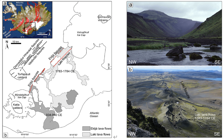
Fig. 2. Left: (a) Iceland, with its main volcano-tectonic rift zones (in red), known as Northern (NVZ), Western (WVZ), Snæfellsnes (SVZ) and Eastern (EVZ) volcanic zones. Box shows location of (b). (b) Location of the Eldgjá and Laki eruptive fissures, and other eruptive fissures. Right: (a) View of NE termination of the 75-km-long Eldgjá eruptive fissure. (b) View of SE portion of the 27-km-long Laki eruptive fissure, with alignment of fractured monogenic cones within graben-like structures. After Brugnatelli and Tibaldi (2020, 2021).
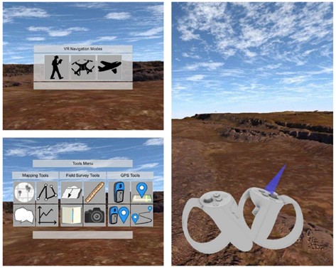
Fig. 3. Top left: Overview of the options available with a new software to navigate into natural environments in virtual reality, to simulate walking, drone flight and aircraft flight modes. Bottom left: Mapping, survey and GPS tools available within the virtual reality. Right: example viewpoint seen by the user when in virtual reality, showing the Oculus Rift controllers and pointer used to interact with the environment. After Harknett et al. (2022).
crop models (DOM) of complex geological sites, that successively can be navigated in 3D Virtual Reality, simulating real world field mapping (Fig. 3). Furthermore, this method allows for subsequent investigation of the virtual site by other research groups, even if the natural field site can no longer be reached for some reason, such as due to subsequent coverage of the site by the deposition of other geological deposits.
3.3 A better understanding of magma pathways to volcanic eruptions
Volcanic eruptions occur only if magma is able to rise from magma chambers to the surface. This magma ascent depends on several variables that have been studied with a multidisciplinary approach. For example, Clunes et al. (2024) have shown that the rock types and geometry of the various rock layers surrounding magma chambers can influence the magma ascent zones. Numerical calculations indicate that with sub-horizontal stratification (Fig. 4 left), the tensile stress induced by the overpressure of the magma above the chamber is greater than in steeply inclined layers (Fig. 4 right). The tensile stress concentration zone represents the rock volume in which magma ascent towards the surface is facilitated. Furthermore, the peak of the tensile stress is further displaced from the center of the magma chamber in the case of steeply inclined layers. These findings facilitate the understanding of the locations where magma can erupt.
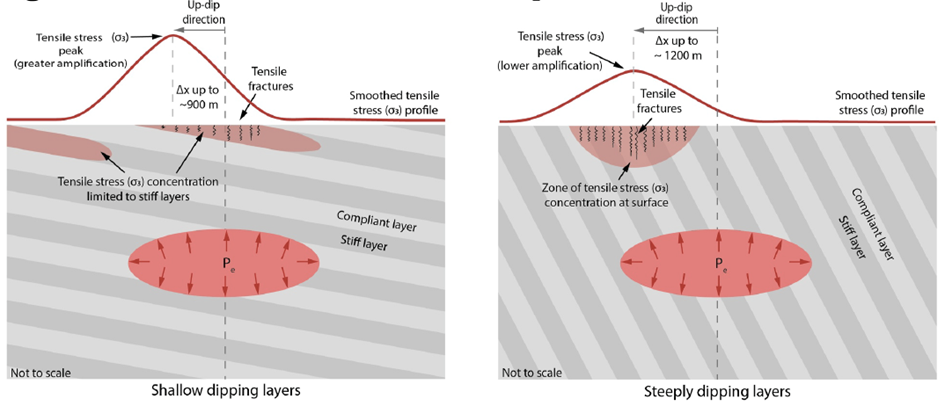
Fig. 4. Schematic illustrations showing the layer dip (grey strips) influence on the stress field around a pressurized magma chamber (red ellipse). Left: Preferential concentration of stresses in stiff layers for a pressurized chamber intruding shallow dipping layers, with greater stress amplification and lower peak location shift. Right: Formation of zones of tensile stress accumulation for a magma chamber intruding steeply dipping layers, with lower stress amplification and greater peak location shift.
Gudmundsson (2025) shows that magma propagates through fractures (dikes) to feed volcanic eruptions. However, most dike segments do not reach the surface to feed volcanic eruptions because dikes stop their upward propagation, commonly at rock layers with contrasting mechanical properties. However, once a dike is formed, its very existence provides a favourable path for subsequent injections of other dikes, giving rise to a composite dike that produces subsequent volcanic eruptions. Sometimes, these composite dikes are represented by injections of mafic basaltic magmas and rhyolitic felsic magmas, as can be seen in Fig. 5. These data suggest that explosive eruptions (typically produced by more felsic magmas) and less dangerous eruptions (typically induced by more basic magmas) can be fed by the same underlying dike.
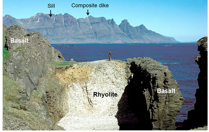
Fig. 5. Composite dikes can be generated through the propagation of magmas of contrasting composition (here mafic rhyolite, and felsic basalt) along the same path. After Gudmundsson (2025).
As a last example, Tibaldi et al. (2025) reconstructed a detailed chronology of the 1947 Mt Etna (Italy) eruption, using local chronicles and historic aerial photos to illustrate the day-by-day development of the area affected by the eruption (Fig. 6). They found that a shallow dike allowed lateral propagation of magma from the volcano summit zone to the northeast flank. The dike followed the path of a previous similar event, remobilizing previous faults induced by an older dike injection. Field data, historical reports and analogue, physically-scaled models, suggest that the surface structures can be formed by the lateral propagation of a dike, whose path depends upon a combination of magma overpressure, local topography, external stresses, and pre-existing fractures.
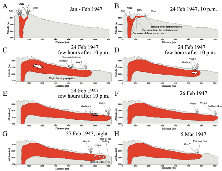
Fig. 6.Detailed reconstruction of the evolution of the 1947 Mt. Etna eruption based on historical data and field surveys, showing the lateral propagation of the dike (red) responsible of the eruption. The sketch represents the shallower part of the volcano (above 1500 m a.s.l.). The height of the dyke is just indicative. After Tibaldi et al. (2025).
Cited references
Brugnatelli, V., & Tibaldi, A. (2020). Effects in North Africa of the 934–940 CE Eldgjá and 1783–1784 CE Laki eruptions (Iceland) revealed by previously unrecognized written sources. Bulletin of Volcanology, 82(11), 73.
Brugnatelli, V., & Tibaldi, A. (2021). Reply to the comment on “Effects in North Africa of the 934–940 CE Eldgjá and 1783–1784 CE Laki eruptions (Iceland) revealed by previously unrecognized written sources”. Bulletin of Volcanology, 83(8), 56.
Clunes, M., Browning, J., Cortez, J., Cembrano, J., Marquardt, C., Kavanagh, J. L., & Gudmundsson, A. (2024). Stresses induced by magma chamber pressurization altered by mechanical layering and layer dip. Journal of Geophysical Research: Solid Earth, 129(5), e2023JB027760.
Gudmundsson, A. (2025). Multiple dikes make eruptions easy. Journal of Volcanology and Geothermal Research, 460, 108284.
Harknett, J., Whitworth, M., Rust, D., Krokos, M., Kearl, M., Tibaldi, A., F.L. Bonali, B. Van Wyk de Vries, V. Antoniou, P. Nomikou, D.Reitano, S. Falsaperla, F. Vitello, Becciani, U. (2022). The use of immersive virtual reality for teaching fieldwork skills in complex structural terrains. Journal of Structural Geology, 163, 104681.
Satow C., Gudmundsson A., Gertisser R., Ramsey C.B., Bazargan M., Pyle D., Wulf S., Miles A.J., Hardiman M., 2021. Eruptive activity of the Santorini Volcano controlled by sea-level rise and fall. Nature Geoscience, 14 (8), 586-592, https://doi.org/10.1038/s41561-021-00783-4
Tibaldi, A., Luppino, A., De Beni, E., Corti, N., Cantarero, M., Mariotto, F. P., & Bonali, F. L. (2025). Effects of lateral dyke propagation and pre-existing fractures on shallow deformation: Data from the Etna 1947 eruption and analogue models. Journal of Volcanology and Geothermal Research, 108349.
Highlights:
[1] A. Tibaldi,A. Luppino,E. De Beni,N. Corti,M. Cantarero,F. Pasquarè Mariotto,F.L. Bonali. Effects of lateral dyke propagation and pre-existing fractures on shallow deformation: Data from the Etna 1947 eruption and analogue models. Journal of Volcanology and Geothermal Research, 2025.
[![]() pdf] [https://doi.org/10.1016/j.jvolgeores.2025.108349]
pdf] [https://doi.org/10.1016/j.jvolgeores.2025.108349]
[2] Agust Gudmundsson. Multiple dikes make eruptions easy. Journal of Volcanology and Geothermal Research, 2025.
[![]() pdf] [https://doi.org/10.1016/j.jvolgeores.2025.108284]
pdf] [https://doi.org/10.1016/j.jvolgeores.2025.108284]
[3] Matías Clunes, John Browning, Jorge Cortez, José Cembrano, Carlos Marquardt, Janine L. Kavanagh, Agust Gudmundsson. Stresses Induced by Magma Chamber Pressurization Altered by Mechanical Layering and Layer Dip. Journal of Geophysical Research: Solid Earth, 2024.
[https://doi.org/10.1029/2023JB027760]
[4] J. Harknett,M. Whitworth,D. Rust,M. Krokos,M. Kearl,A. Tibaldi,F.L. Bonali,B. Van Wyk de Vries,V. Antoniou,P. Nomikou,D. Reitano,S. Falsaperla,F. Vitello,U. Becciani. The use of immersive virtual reality for teaching fieldwork skills in complex structural terrains. Journal of Structural Geology, 2022.
[![]() pdf] [https://doi.org/10.1016/j.jsg.2022.104681]
pdf] [https://doi.org/10.1016/j.jsg.2022.104681]
[5] Satow, C., Gudmundsson, A., Gertisser, R. et al. Eruptive activity of the Santorini Volcano controlled by sea-level rise and fall. Nat. Geosci. 14, 586–592 (2021).
[https://doi.org/10.1038/s41561-021-00783-4]